
Architectural Visualisation Barn Conversion



Architectural Visualisation Barn Conversion
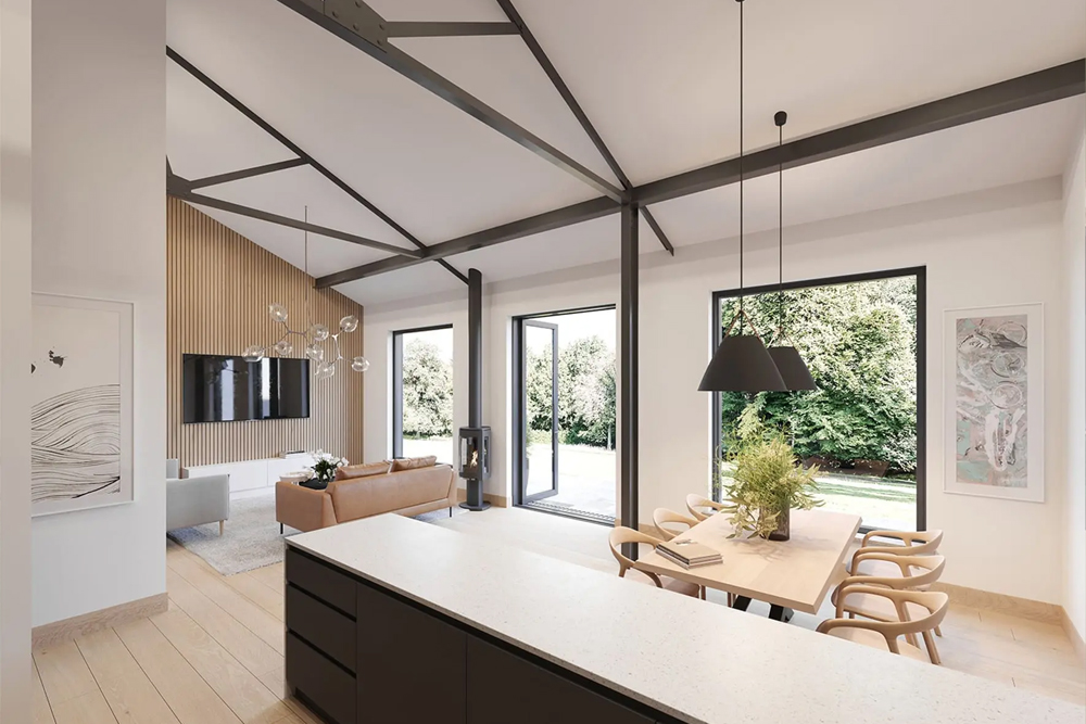
This architectural visualisation barn conversion by Charles Roberts Studios presents a clear and carefully considered transformation of a rural agricultural site into a refined residential development. Through the use of high-resolution drone photography and accurately aligned CGI, the project demonstrates how architectural visualisation can communicate complex rural redevelopment proposals with clarity, credibility, and visual confidence.
Barn conversions occupy a uniquely sensitive position within residential architecture. They require a balance between preserving rural character, respecting historical context, and delivering homes that meet contemporary expectations of comfort, sustainability, and spatial quality. Architectural visualisation plays a vital role in bridging these requirements by translating drawings and planning data into imagery that can be easily understood by planners, neighbours, consultants, and future buyers alike.
Read more about this project …
Reimagining Rural Architecture Through Visualisation
Rural redevelopment is often subject to closer scrutiny than new-build housing, particularly where agricultural buildings sit within open countryside. An architectural visualisation barn conversion must therefore do more than look attractive. It must explain how the proposal responds to its environment, how scale and massing are managed, and how the development improves rather than erodes the character of the site.
In this project, the visualisation provides a clear narrative of transformation. It shows how a working agricultural compound, previously defined by utilitarian structures and informal circulation, is reimagined as a cohesive residential setting that remains rooted in its rural origins.
The Existing Site and Its Constraints
The starting point for the architectural visualisation is a detailed understanding of the existing site conditions. Drone photography captures the current agricultural layout, including steel-framed barns, storage areas, vehicle yards, temporary materials, and active construction zones. The surrounding context of open fields, hedgerows, tree belts, and neighbouring properties is clearly visible, establishing a factual baseline for planning and design discussions.
This existing condition imagery is essential. It demonstrates that the site already has a developed footprint and operational character, helping to frame the proposal as a considered conversion rather than an inappropriate new intervention in the countryside. Architectural visualisation builds directly on this reality, ensuring the proposal remains grounded in what is physically present.
From Agricultural Use to Residential Form
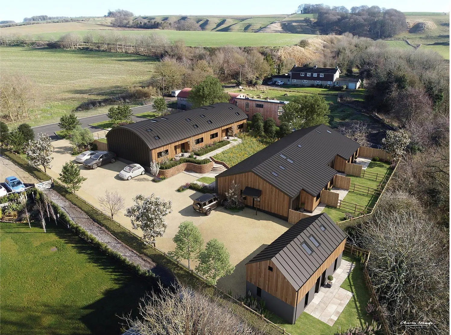
The architectural visualisation barn conversion illustrates how agricultural buildings are adapted into residential forms without losing their original identity. The CGI shows a composition of buildings that retain simple, robust volumes and pitched roof profiles, echoing traditional barn typologies while introducing refinement through proportion, detailing, and material choice.
Rather than forcing domestic styling onto the architecture, the visualisation demonstrates restraint. Long elevations, limited openings, and coherent rooflines maintain the agricultural rhythm of the site. This approach is particularly important in planning contexts, where over-domestication can undermine the perceived authenticity of a barn conversion.
The Value of Aerial CGI in Planning Submissions
Aerial CGI is central to the success of this architectural visualisation barn conversion. While plans and elevations explain individual buildings, aerial views reveal how the entire site functions as a whole. The CGI shows the relationship between buildings, access routes, parking areas, private gardens, shared spaces, and the surrounding landscape.
This perspective closely mirrors how planning officers assess rural developments. It allows them to understand massing, density, and spatial hierarchy at a glance. When paired with drone photography taken from comparable viewpoints, the visualisation provides an immediate and credible explanation of change.
Accuracy and Trust in Architectural Visualisation
A defining characteristic of this project is the accuracy of the CGI in relation to the real site. Camera heights, angles, site boundaries, and topography are carefully matched to the drone photography. This ensures that scale relationships feel believable and that the proposed development sits naturally within its surroundings.
For planners, this accuracy builds confidence that the proposal has been honestly represented. For clients, it reduces uncertainty. For buyers, it establishes trust that the finished development will closely reflect what is shown. In architectural visualisation barn conversion projects, this level of fidelity is essential.
Material Language and Architectural Character
Material selection is one of the most scrutinised aspects of rural planning. The architectural visualisation communicates a restrained and contextually appropriate palette that reinforces the barn typology while introducing contemporary quality.
Timber cladding softens elevations and echoes traditional agricultural finishes. Dark standing-seam metal roofs provide durability while maintaining a quiet visual presence in the landscape. Brick and masonry elements ground the buildings and reference local construction traditions. Window openings are carefully proportioned to balance light and privacy without disrupting the integrity of the barn forms.
The visualisation allows planners and stakeholders to assess these choices holistically, rather than interpreting them in isolation through specification documents.
Landscape Integration and External Space
Landscape treatment is integral to the success of any barn conversion. The architectural visualisation shows how open space, planting, and boundaries are used to integrate the development into its rural setting rather than impose a suburban character.
Gardens are defined but not enclosed excessively. Hedgerows, trees, and planting soften transitions between built form and open fields. Shared and private spaces are clearly legible, while parking and access are handled discreetly. The aerial view makes these relationships immediately understandable, supporting both planning approval and long-term liveability.
Circulation, Access, and Functionality
Beyond aesthetics, the architectural visualisation barn conversion clearly demonstrates that the site functions as a practical residential environment. Vehicle access routes, turning areas, and parking arrangements are logically resolved and visually explained. Pedestrian movement between buildings feels natural, and service areas are integrated without dominating the site.
By resolving these practical considerations visually, the CGI answers many of the operational questions that typically arise during planning assessment.
Supporting the Planning Narrative
Architectural visualisation does not replace technical documentation, but it strengthens it. In this project, the CGI acts as a visual summary of the planning narrative, reinforcing arguments around the reuse of existing structures, enhancement of rural character, and improvement of landscape quality.
Rather than relying solely on written justification, the visualisation allows decision-makers to see the outcome directly. This clarity often accelerates understanding and reduces ambiguity during planning discussions.
From Planning Approval to Property Marketing
Once planning approval is secured, the same architectural visualisation barn conversion becomes a powerful marketing tool. Barn conversions attract buyers seeking individuality, character, and countryside living, often well before construction is complete.
The aerial CGI enables developers and agents to communicate the setting, layout, and quality of the scheme with confidence. Because the imagery is rooted in real site photography, it avoids the artificial feel that can undermine buyer trust in off-plan marketing.
The Role of Charles Roberts Studios
Charles Roberts Studios specialises in architectural visualisation for sensitive rural and heritage-led projects. Barn conversions require an understanding of planning constraints, architectural restraint, and landscape context that goes beyond technical rendering skill.
By combining drone photography with carefully calibrated CGI, the studio produces architectural visualisation barn conversion imagery that prioritises accuracy, credibility, and clarity. The focus is always on explaining design intent rather than exaggerating it.
Before and After as a Complete Visual Story
The pairing of existing drone photography with proposed CGI creates a complete and compelling visual story. It shows where the site begins, how it evolves, and what it becomes. This comparison is invaluable for planners, stakeholders, and the public, particularly in rural contexts where change must be carefully justified.
Together, the images demonstrate that the proposal is not an intrusion but an evolution, improving the site while respecting its history and setting.
Conclusion
This architectural visualisation barn conversion illustrates the true value of CGI in rural redevelopment. By grounding the visualisation in real-world photography and prioritising accuracy over spectacle, Charles Roberts Studios has created imagery that supports planning approval, enhances understanding, and underpins future marketing.
In barn conversion projects, where sensitivity, trust, and clarity are paramount, architectural visualisation is not simply a presentation tool. It is a fundamental part of the design and approval process, enabling rural architecture to be understood, assessed, and ultimately realised with confidence.
Contact

20-22 Wenlock Road
London
N1 7GU
[email protected]
+44 (0) 203 026 7100
USA Site
Follow Us
Sectors
Studio
Copyright © 1995 -
All rights reserved