

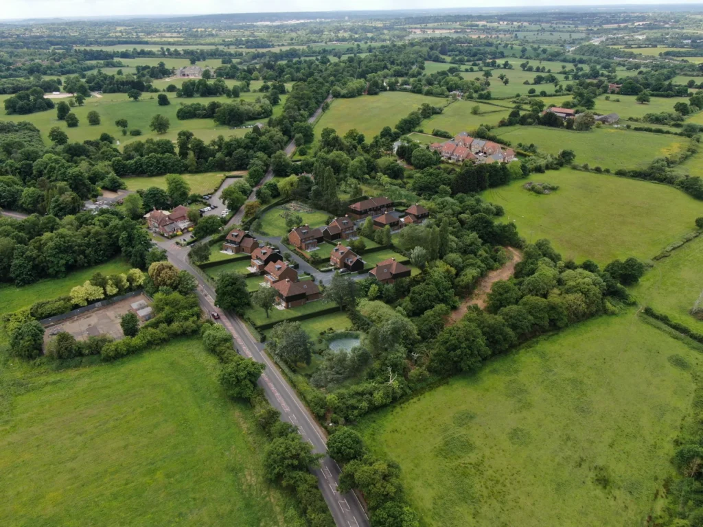
At Charles Roberts Studios, some of the most rewarding projects are those that help people see the potential in a site that may otherwise be difficult to read. This former garden centre redevelopment was a strong example of that. Using aerial drone CGI, we were able to transform a complex existing setting into a clear and compelling visual story, showing how the site could evolve into a well-planned residential development set comfortably within the surrounding landscape.
Sites with a previous commercial use often require a different kind of visual communication. Existing buildings, hardstanding, access arrangements and layers of planting can make it hard to understand the opportunity from ground level alone. Even when the design proposal is strong, plans and technical drawings do not always make that future vision immediately accessible. Aerial CGI helps bridge that gap. It allows the wider shape of a scheme to be understood at a glance, placing architecture, landscaping and context into a single, coherent image.
For this project, the goal was not simply to create attractive visuals. It was to present a former garden centre site as a refined and believable place to live.
Revealing the Opportunity of the Site
The existing site sat within an attractive green setting, surrounded by mature trees, open fields and neighbouring residential areas. Although it had clear redevelopment potential, its previous use meant that much of that potential needed to be interpreted rather than immediately seen. This is often the case with former garden centres and similar brownfield-style sites. They may occupy strong locations, but they can appear fragmented or visually unresolved in their current condition.
Our role was to help clarify the opportunity. By combining real drone photography with carefully integrated CGI, we were able to show the site as a complete residential proposal rather than a leftover commercial landscape. The visuals re-framed the conversation. Instead of focusing on the existing condition, they highlighted the quality of the future development, the logic of the layout and the strength of the landscape setting.
This shift is often one of the most valuable outcomes of architectural visualisation. It gives clients, planners and stakeholders something tangible to respond to. Rather than imagining what the site might become, they can see it with clarity.
Why Aerial Drone CGI Was So Effective
Aerial drone CGI is particularly powerful on sites where layout and context are central to the story. Street-level images are invaluable when showing the character of a house type or the experience of arrival, but aerial views provide something different. They explain the bigger picture. They show how a site sits within its surroundings, how access works, how plots are arranged and how the development relates to landscape features beyond the site boundary.
That was especially important here. The setting was a key part of the appeal, and the scheme needed to feel integrated into that setting rather than imposed upon it. The aerial views made that immediately legible. They showed a residential development enclosed by mature greenery, connected to the surrounding road network and balanced carefully against the wider countryside.
This kind of overview is helpful not only for design teams, but also for clients and non-specialist audiences. A good aerial CGI removes ambiguity. It provides a clear visual explanation of a scheme in a way that plans alone rarely can.
A Development That Sits Within the Landscape
One of the most important qualities of these visuals is the way they present the development as part of a wider landscape structure. The homes are not shown as isolated objects or as a dense block of building mass. Instead, they are set within a framework of trees, gardens, hedges and open space that gives the whole proposal a softer and more established feel.
This was central to the success of the imagery. Residential developments in greener or semi-rural settings are often judged as much by their landscape treatment as by the architecture itself. A scheme needs to feel comfortable in its surroundings. It needs to suggest maturity, restraint and a sense of belonging. Through the use of retained planting, clearly defined gardens and carefully composed open space, the visuals helped communicate exactly that.
From above, the development reads as calm and well balanced. There is structure, but there is also softness. The planted boundaries help shape the plots without feeling harsh, while the wider greenery helps the site settle naturally into the landscape. This was important not only visually, but strategically. It reinforced the idea that the proposal was responding to the site rather than overwriting it.
Two Views, One Story
The two aerial images worked together to tell the story of the project. Each view offered a slightly different emphasis, allowing the proposal to be read from more than one perspective.
One image focused more strongly on the site’s relationship to the surrounding roads, neighbouring homes and broader green context. It helped explain where the development sat within the area and gave a clear sense of access and placement. The second brought the viewer closer to the internal structure of the scheme, revealing more of the arrangement of the homes, the shape of the plots and the way landscape elements helped define the character of the development.
Together, the pair of visuals created a more complete narrative than a single image alone could provide. One established context. The other explored composition and character. This is often the most effective approach in aerial property CGI, particularly when a scheme needs to be understood at both strategic and human levels.
Moving Beyond the Existing Use
A key part of the success of this project was the ability of the visuals to move the conversation beyond the site’s former use. Old garden centre sites can often be difficult to market or present in their current state, even when they are well located. Their previous function can dominate perception. Viewers may focus on what is there, rather than what could be achieved.
The CGI helped overcome that. It replaced uncertainty with a clear development vision. It showed that the site was capable of becoming something cohesive, attractive and valuable. That transformation is one of the great strengths of high-quality property CGI. It does not invent something disconnected from reality, but it allows the best future version of a site to be understood in a direct and convincing way.
For developers and landowners, this can be especially important. Strong visuals can support planning submissions, stakeholder engagement, land promotion and early-stage marketing by giving everyone a more confident understanding of the scheme.
The Importance of Real Photography
Using real drone photography as the base for the CGI gave the final images an authenticity that is difficult to achieve through digital modelling alone. The surrounding trees, fields, roads and neighbouring buildings are all rooted in reality, which helps the proposal feel grounded and credible from the outset.
This is one of the reasons aerial drone CGI is such an effective medium. It combines the precision and flexibility of CGI with the honesty of real-world context. The result is a visual that feels persuasive without becoming overstated. It allows the proposed development to be seen exactly where it will sit, within the real landscape that surrounds it.
At Charles Roberts Studios, this balance is central to our approach. We are always aiming to create visuals that are not only attractive, but useful. They should help people understand design, assess context and engage with a proposal confidently.
A Valuable Tool for Planning and Presentation
While these images are visually engaging, their real value lies in communication. For planning teams, they help explain the scale and arrangement of a development more clearly. For clients, they provide reassurance and help bring a proposal to life. For wider stakeholders, they make a scheme easier to interpret and evaluate.
That is particularly true on sites with an existing use that no longer reflects the land’s best potential. In those cases, a good visual can be transformative. It allows a proposal to be judged on the strength of its design and layout rather than the limitations of the site’s current appearance.
This former garden centre redevelopment was exactly that kind of project. The aerial CGI helped reveal a site that could become a thoughtfully planned residential setting with a strong relationship to its landscape and context.
Bringing Clarity to Development Potential
This project is a good example of how aerial drone CGI can bring clarity, confidence and quality to the presentation of a development site. By showing the proposed scheme within its real surroundings, the visuals helped communicate not only what was planned, but why it worked.
The former garden centre was reimagined as a residential development with structure, greenery and a clear sense of place. The aerial views captured that transformation in a way that was immediate and easy to understand. They showed the site’s potential, the strength of the proposed layout and the value of presenting architecture within its full landscape context.
For sites like this, that level of clarity can make all the difference. It helps move a project from concept to conviction.
